
Everglades National Park is the largest tropical wilderness in the United States and was created to protect the fragile ecosystem of the South Florida wetlands. The park is one of three places in the world to be concurrently listed as a World Heritage Site, a Biosphere Reserve, and a Wetland of International Importance. The Everglades overlie the recharge zone of the Biscayne Aquifer and are the source of the majority of South Florida's fresh water supply.
Before construction of US Highway 41 ("Tamiami Trail") west of Miami, Florida in the 1920s, fresh water was free to flow south through Florida to feed the Everglades wetlands. The Tamiami Trail essentially blocked the flow of water, and plans were made to drain the swamp for agricultural and residential use as water was diverted to Miami and other nearby cities. The reduction in fresh water levels in the park allows salt water intrusion to occur, damages the Everglades ecosystem, and negatively impacts the biodiversity found in the park. It has been estimated that every dollar spent on preservation of the park ecosystem generates four dollars in return.
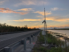
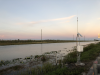
Major canal-building projects began in the 1930s and 1940s to protect the vanishing Everglades—including the canal adjacent to the Tamiami Trail, which feeds upstream fresh water to the park. High water levels in the canal are essential to push water into the Everglades through culverts and under bridges but can also damage the road base and endanger motorists. To prevent highway damage, the Florida Department of Transportation (DOT) limits the water level in the canal to 7.0 feet NAVD88. Thus exists a fine balance of maintaining high water levels and protecting the road base.
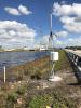
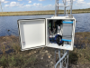
RESPEC installed six monitoring sites for the park along the Tamiami Trail to monitor water level in the canal, water level in the subsurface soil near the road base, and soil water content underneath the road base. Sensors include Amazon bubblers, Geokon vibrating wire piezometers, and Campbell Scientific CS650 soil moisture probes and CS100 barometric pressure sensors mounted in Campbell enclosures on UT10 towers. The towers are constructed to withstand hurricane-force winds and are grounded with CAD welds. Data is collected by Campbell Scientific CR300-CELL205 dataloggers at 15-minute intervals and transmitted once per hour via cellular link to the Eagle.io web dashboard where stakeholders can view and download data. The real-time system sends email or text notifications when current water- and soil-moisture levels exceed preset thresholds. Likewise, the system allows the Everglades National Park Service and Florida DOT to coordinate a proper response.
Case Study Summary
Application
Monitor soil moisture and canal water level to protect highwayLocation
Miami, FLProducts Used
KonectGDS CS650 CR300 CS100 AVW200 UT10Contributors
Eric Krantz, RESPECMeasured Parameters
Water level (VW transducer), water level (bubbler), soil moisture, barometric pressureParticipating Consultants/Integrators
RESPECView the PDF