This product is not available for new orders. We recommend ordering: SkyVue PRO.
| Services Available |
|---|
Overview
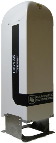
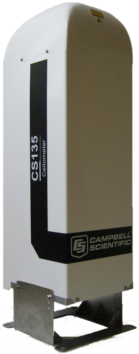
The CS135 LIDAR Ceilometer measures cloud height and vertical visibility for meteorological and aviation applications. Using LIDAR (light detection and ranging) technology, the instrument transmits fast, low-power laser pulses into the atmosphere and detects back-scattered returns from clouds and aerosols above the instrument.
The CS135 complies with CAA and ICAO guidance and meets or exceeds all recommendations and specifications. (This includes CAP437, CAP670, and CAP746.)
Tilt capability to 24° allows the sensor to be operated anywhere in the world without the sun shining directly into the lens.
Read MoreBenefits and Features
- Single lens design
- Robust, reliable Campbell Scientific electronics
- Mixing Layer Height assessment for air quality applications (feature requires a key to unlock at extra charge)
- Reports cloud height and sky condition to WMO and ICAO recommendations
- State-of-the-art signal processing
- Competitive pricing
- Built-in stratocumulus-based calibration
- Dual clock comparison for confidence in reliable operation
- Integrated heater, blower, and radiation shield
- Filter to protect detector from direct sunlight
Images
Detailed Description
The CS135 employs a single lens design to increase optical signal-to-noise ratio over other instruments. One half of the lens is used for the transmitter and the other for the receiver with total optical isolation between them. This allows it to have exceptional performance with low altitude overlap between the transmitter and receiver, allowing lower altitude measurement and integrating larger optics into a compact package. The optics are also immune to damage from direct sunlight.
This approach, along with state-of-the-art electronics, provides a powerful and stable platform from which to measure cloud height and vertical visibility to high accuracy. With a rugged environmental enclosure that protects the instrument from the harshest conditions, the CS135 measures the atmosphere with high stability and repeatability.
The CS135 can be tilted up to 24º. Cloud heights are automatically corrected. A small tilt is an important feature, as it allows the CS135 to resist high levels of reflection from large raindrops and frozen particles that can impair a vertical sensor. Tilting to 24º means that it can be operated anywhere in the world without the sun shining into the lens and resulting in missing data. (The options are, however, immune to damage from direct sunlight.)
The CS135 provides information on cloud height, sky condition (up to five layers), vertical visibility, and raw backscatter profiles.
As an option, Mixing Layer Height can be calculated within the CS135 and inserted in data messages.
It has a unique stratocumulus calibration capability for accurate measurements of scatter coefficients.
Reliable range measurement is assured by cross-checking two internal clocks.
Mixing Layer Height assessment for air quality applications**
Mixing Layer Height (MLH) is an important parameter in modeling air quality and predicting air pollution episodes. It is also a very difficult parameter to measure without expensive sounding systems. The new operating system includes an MLH assessment option.
This retrieves the height of the mixed aerosol layer by applying the gradient method to the ceilometer’s backscatter signal. The automated process is based on the operational algorithm used by KNMI* and searches for the drop in backscatter associated with the transition from boundary layer aerosols to free troposphere. Because the signals measured depend on the type and amount of aerosol present, as well as the background light level, the accuracy of the method varies. Therefore, a quality factor is assigned, which indicates the confidence in the reported layer height.
The algorithm runs within the CS135 itself, and the results are incorporated in data messages, making it easy to incorporate the MLH into whatever systems are already in use without the need to run external special software. It is activated by an alphanumerical "key."
*Determination of mixing layer height from ceilometer backscatter profile, Marijn de Haij; Wiel Wauben; Henk Klein Baltink
Proc. SPIE6362, Remote Sensing of Clouds and the Atmosphere XI, 63620R (October 11,2006): doi:10.111/12.691050
Read a white paper Comparison of Mixing Layer Height Retrieved By Ceilometer and Doppler Lidar
** Chargeable extra
Stratocumulus based calibration
Calibration of the actual magnitude of the scatter returned by a ceilometer is not simple. The CS135 now includes a process to make this calibration easier for users looking for more information than basic cloud height or sky condition. Reliable values for scatter coefficients are important for research applications, as well as if ceilometer raw scatter profiles are to be compared between locations or over time, for example in cloud studies or following the location of plumes of pollution or ash.
The attenuated backscatter is calibrated by an automated process based on the method developed by O’Connor et al (2004)*. The method uses the well-understood scattering properties of a fully attenuating stratocumulus cloud as a reference. The calibration requires a stable stratocumulus layer with no precipitation present. The integrated lidar signal measured can then be scaled to match the expected integrated attenuated backscatter. This is carried out in response to a set of simple commands entered via a serial link.
The CS135 can output a scatter profile with a 5 m resolution at intervals between 2 and 600 seconds.
*O'Connor, Ewan J., Anthony J. Illingworth, and Robin J. Hogan. "A Technique for Autocalibration of Cloud Lidar." Journal of Atmospheric & Oceanic Technology 21, no. 5 (2004).
Inclinometer
The response time of the inclinometers on the CS135 has been reduced to two seconds. This means it can return accurate, tilt corrected, cloud heights from moving platforms such as floating offshore structures or large warships. The CS135 has inclinometers in two axes, and the correction for cloud height is totally automatic.
Clock checking
The accuracy of a cloud height measured by a ceilometer ultimately depends on the accuracy of the built-in clock used to measure the return time of scattered laser pulses. The CS135 provides a check on the accuracy of the main processor clock by comparing it with the output of an independent electronic clock. Any discrepancy will trigger an alarm.
Heater/blower control
The new OS includes a more sophisticated system of heater/blower control, taking into account the presence of cloud and window contamination.
Viewpoint display software
Ceilometer data can now be conveniently displayed using the Viewpoint software. This will display the output from the ceilometer in a convenient and completely configurable form. Sky condition, mixing layers, scatter profiles, etc., can all be displayed simultaneously or separately with ranges and time scales configurable.
Specifications
| Measurement Description | Cloud height and vertical visibility |
| Signal Type/Output | RS-232, RS-485 |
| Temperature Range |
|
| Battery Temperature Range | -20° to +50°C (Alternative battery types with wide temperature ranges can be supplied to achieve the -40° to +60°C range.) |
| Humidity Range | 0 to 100% RH |
| IP Rating | IP66 (NEMA 4x) |
| Dimensions | 100 x 33.0 x 31.6 cm (39.4 x 13.0 x 12.4 in.) including base |
| Shipping Dimensions | 120 x 45.0 x 45.0 cm (47.2 x 17.7 x 17.7 in.) |
| Weight |
|
| Shipping Weight | 58 kg (127.9 lb) |
Instrument Performance |
|
| Reporting Range | 0 to 10 km (0 to 32,808.4 ft) |
| Minimum Reporting Resolution | 5 m (15 ft) |
| Hard Target Range Accuracy | ±0.25%, ±4.6 m |
| Reporting Cycle | 2 to 120 s |
| Cloud Layers Reported | Up to four layers |
| Sky Condition | Up to five layers with cover in oktas according to WMO requirements for SYNOP and METAR codes |
| Vertical Visibility | Reported when no clouds selected |
| Laser Wavelength | 912 nm (±5 nm) |
| Eye Safety Standard | Class 1M |
| Maximum Wind Speed | 55 m/s |
Electrical |
|
| Power | 110, 115, 230 Vac ±10%, 50 to 60 Hz, 470 W maximum |
| Battery |
Internal 12 Vdc, 2 Ah battery backup Provides 2 h measurement, without blower/heater, in the event of mains failure. |
Interfaces |
|
| Data Interfaces | RS-232, RS-422, RS-485, Ethernet |
| Maintenance Interfaces | USB 2.0 (USB 1.1 compatible) |
| Baud Rate Interfaces | 300 to 115200 bps |
Compliance |
|
| Laser Safety Compliance | EN60825-1:2001 |
| Electrical Safety Compliance | EN61010-1 |
Documents
Case Studies
Campbell Scientific’s system integrator, AUDIMOBIL LDA, recently upgraded the airport weather system in the S.......read more
AUDIMOBIL recently installed an Automatic Weather Station in a Portuguese Military Air Base, to support......read more
Privacy Policy Update
We've updated our privacy policy. Learn More
Cookie Consent
Update your cookie preferences. Update Cookie Preferences