Enables collection, viewing, and analysis of monitoring data


Overview
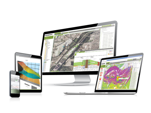
MultiLogger Suite is a versatile, integrated, data management platform, with an intuitive interface to collect, view, and analyze monitoring data. MLSuite is suited for projects of all sizes, including very large deployments, and the platform can be used seamlessly for manual and automated data collection. MultiLogger interfaces directly with all types of Campbell Scientific data loggers, allowing the programming of direct data collection in a simple, point-and-click interface without the need for LoggerNet (but it works with LoggerNet, too).
Easy to deploy without the need for web programming or development, MLSuite can be run over an intranet or the Internet, or installed locally on a desktop. MLSuite offers many data visualization and management options, including the following: powerful notification and reporting features that help translate raw data into decisions and actions quickly, full GIS map server integration, 3D visualization, comprehensive document management including photos and videos, and a free field data entry app, MLField.
Read MoreBenefits and Features
- Single Integrated Platform ― A single integrated platform with an intuitive interface to view and analyze monitoring data
- Data Logger Control ― Update programming and data collection directly with a simple point-and-click interface
- Desktop, Intranet, and Internet ― Provides data access to the project database via intranet/Internet, on mobile devices, and/or locally via desktop client software
- Easy Deployment ― Requires no custom web programming or development; install and run
- From Data to Action ― Powerful notification and reporting options to help translate raw data into decisions and actions
- Collaboration made easy ― Easy export and sharing options allow easy collaboration with colleagues
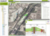
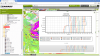
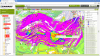
- GIS Integration ― Support for ArcGIS map server integration, including InSar satellite data
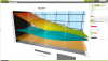
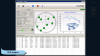
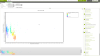
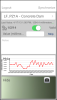
- Chart Flexibility ― Visualize and cross-reference multiple data types on the same chart
- Formulas and Calculations ― Powerful custom calculations engine for complex data management and analysis
- Historical Data ― Powerful import options to merge historical data seamlessly with ongoing collections in just a few clicks
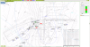
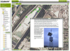
- Project Overview at a Glance ― Single point of interaction to monitor current project status, including alarms, uploaded photos, and field notes
- Customizable ― Features fully customizable data viewing and data entry forms
- Scalable ― Manage one project or connect to and combine dozens of databases from the convenience of a desktop
- Secure ― State-of-the-art, secure Microsoft .NET technology for granular user access control
- Field Data Entry ― Free MLField app for seamless linking of manual data collection in the field, including notes and photos, with the integrated project database
- Buy it once ― No ongoing subscription costs; a single purchase with a cost that scales with the size of the project
- Always Up to Date ― Actively supported and updated regularly with new features, at no additional cost
- Professional Support ― Professional staff of engineers to provide support for all aspects of data collection, including software, instrumentation, and data analysis
Images


Detailed Description
MultiLogger Suite is the only tool needed to effectively and efficiently collect, manage, and analyze data for any type of project—be it geotechnical, structural, meteorological, environmental, construction, or other. Designed as an integrated platform from the ground up, MLSuite seamlessly works with and connects all aspects of a monitoring project in a single platform. This approach opens powerful possibilities for cross-referencing any type of data, for alarming and notifications based on real-world complexity, as well as for effective reporting and risk management. In short, MLSuite is capable of presenting, at a glance, the status of a given project as a whole, in a single integrated view.
MLSuite connects seamlessly with any Campbell Scientific data logger, providing for programming and data collection with a simple point-and-click interface without the need for LoggerNet. A variety of sensors can be interfaced directly as well, including Total Stations, GPS, Seismic recorders, and others.
MLSuite can be deployed on a server for display in any browser on an intranet network or the Internet. Alternatively, it can be installed locally on a desktop or local network, and viewed and managed in dedicated desktop client tools. Deployment, installation, and project setup are quick and easy and do not require any custom coding or development.
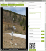
MLSuite can be used with fully Automated Data Acquisition Systems (ADAS), as well as for manually collected and historical data, and any mix in-between. Powerful data import options including data file import, and database connections such as SQL, ODBC, and OPC (such as PI and SCADA), allow access to virtually any type of data and sensor. The MLField mobile app for Android or iPhone/iPad provides an easy way to seamlessly integrate manually collected data in the field with the master database, including notes and site photos. MLField features QR technology to identify instrument locations in the field, synchronizes data automatically when a connection is available (and stores it if it's not), automatically validates data entry against existing thresholds, and allows for viewing of related data on a mobile device.
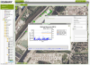
MLSuite uses state-of-the-art security protocols based on Microsoft .NET technology, exceeding other common web standards, and allowing for granular and secure user access control to project data. This includes five configurable levels of user privileges (System Admin, Database Admin, Project Admin, Technician and Guest) and Active Directory integration for single sign-on.
Specifications
| Minimum Server Requirements |
|
| Recommended Server Requirements |
|
| Minimum Client Resources |
|
| Recommended Client Resources |
|
Case Studies
Canary Systems, Inc., was asked by the instrumentation contractor for the new Portugués Dam in......read more
Privacy Policy Update
We've updated our privacy policy. Learn More
Cookie Consent
Update your cookie preferences. Update Cookie Preferences